

The Denmark Strait, also popularly known as the Greenland Strait, is situated in the Arctic Circle between Greenland and Iceland. To the strait’s northwest lies Greenland, while Iceland is located on its southeastern side.
The Denmark Strait is quite famous for not one but a multitude of reasons which will be explored in this article.


The Greenland Strait or Denmark Strait spans 480 km or 300 miles. It is 290 km or 180 miles broad at its narrowest point, which lies between the Straumnes. It is approximately 191 metres deep at the deepest point.
This oceanic strait functions like a gateway, connecting the Greenland and Irminger Sea waters. In this manner, it also links the 2 oceans in the Northern Hemisphere, which are the Arctic and the Atlantic.
This is because the Greenland Sea is seen as an extension of the Arctic Ocean while the Irminger Sea is viewed as a part of the Atlantic Ocean.
Both the Greenland and Irminger Seas are magnificent water bodies on this planet earth.
The Greenland Sea is bordered by Greenland from the west and Svalbard Archipelago from the east. From the south, it is bounded by Iceland and the Denmark Strait. Fram Strait and the Arctic Ocean surround it from the north.
Interestingly, geological surveys have shown that about 13% of the planet’s undiscovered oil reserves and 30% of gas pockets are probably somewhere in the Arctic. Hence, there is a possibility that the Greenland Sea might be home to huge quantities of natural gas, followed by natural gas liquids and also crude oil.
Irminger Sea is considered to be a marginal water body of the North Atlantic. It is one of the principal areas for catching rose fish.
The Sea was named after Carl Ludvig Christian Irminger, a Danish Vice-Admiral. He was known for his bravery when he captured a pirate ship in the West Indies in the 1800s. Additionally, the Irminger Current was also named after him.
Southern Greenland borders the Irminger Sea from the west, while its northern side faces Iceland and Denmark Strait. Reykjanes Ridge surrounds it from the east, and on the south are the open waters of the North Atlantic Ocean.
Jan Mayen is a remote Norwegian island lying in the Arctic Ocean. It is around 920 km west of Norway and approximately 600 km northeast of Iceland. The island measures 55 km lengthwise and spans 373 square kilometres with a sparse population.
It is known for the Beerenberg volcano, the northernmost active volcano in the world. The island is also home to a weather station.


It is quite inaccessible and has no proper airports or ports, only offshore anchorages. One can come here by boat; however, access is restricted to only research and military personnel.
Since it is a desolate place, it is known for its pristine environment and wildlife, including arctic foxes, seabirds and reindeer.
The mountainous island is partly clad with glaciers and has three lakes as well. Created by the Jan Mayen hotspot, geologists have defined it as a microcontinent.
An economically viable resource procured from the island is gravel, found at a site called Trongskaret. It is also rich in fisheries.
The Denmark Strait is a narrow passage connecting the Arctic Ocean with the North Atlantic Ocean and serves as an important pathway for the East Greenland Current.
The East Greenland Current lies off the eastern coast of Greenland. It goes through the Denmark Strait and also the Nordic Sea. While moving through the Denmark Strait, it transports icebergs from the Arctic Ocean to the North Atlantic Ocean.
These icebergs are dangerous and pose a threat to navigation in the North Atlantic. They also affect other ocean currents and climate patterns.
The East Greenland Current is formed due to the convergence of many small currents originating in the Arctic, like the Fram Strait Current and Transpolar Drift. When it flows in the southward direction, it carries the cold and dense water of the Arctic into the North Atlantic and also helps drive global ocean circulation.
Interestingly, the Denmark Strait is home to the world’s largest or highest underwater waterfall, called the Denmark Strait Cataract. The waterdrop or waterfall lies on the western part of the Strait and is approximately 2000 ft or 61 metres below the level of surface water.
The Cataract was first discovered in 2012 by a team of researchers and scientists from the Scottish Association for Marine Science and the University of Bergen, Norway. They used various oceanographic measurements and computer modelling techniques.
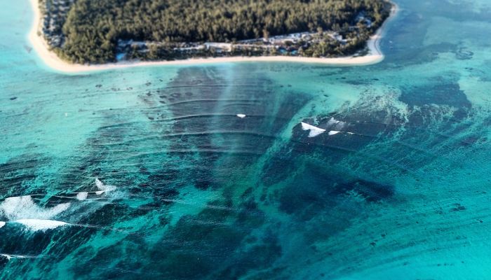

The mighty waterfall is 160 km or 100 miles wide, and the water plunges to an estimated 11,500 ft or 3505 metres. The drop happens from the Greenland Sea into the Irminger Sea.
The astonishing natural phenomenon occurs due to a difference in temperature between the water bodies lying on both sides of the Denmark Strait.
The Nordic Sea and the Greenland Sea contain cold water that is dense and heavy than the warm water of the Irminger Sea. Hence, the cold water does not straightaway mingle with the warm water and instead sinks or plunges to the ocean floor, forming the gigantic Denmark Strait Cataract.
This cold water sinks to the strait’s bottom and flows southward along the continental slope of Greenland.
It is also said to be the largest waterfall in the world by the volume of water flow. It is estimated that the cataract transports water at a rate of 175 million cubic m per second, equivalent to over 200 times the combined flow of all the world’s rivers.
The Denmark Strait is known for its strong currents and icebergs that hinder navigation in the region. This is why there are many ports along the coastline of Greenland and Iceland, but there are no ports or harbours situated directly on the Strait.
One of the major closest ports to the Denmark Strait is Nuuk, located on Greenland’s western coast. Nuuk is also the capital and the biggest city in Greenland, and it also functions as a hub for commerce, trade and transport in the region.
Iceland also has several ports that lie in proximity to the Denmark Strait. One such facility is Reykjavik, one of the most important ports on the southwestern coast of Iceland. Other ports include Stykkisholmur, Akranes and Patreksfjorour.
These ports are crucial for maritime trade in the region, connecting Iceland and Greenland with other parts of the world.
Fisheries in the Strait are mainly focused on harvesting cold-water species like cod, haddock, capelin and redfish.
However, the tradition of fishing in the waters of the Strait has a long history. Presently, it is important for the economy and livelihood of the people of Greenland and Iceland. The fishermen of these nations typically use longliners, trawlers and gillnets to catch fish.
Recently, there has been increasing concern regarding the impact of global warming and climate change on the region’s fish stocks. Warming of the oceans and changes in currents have led to changes in the distribution of fish populations. Hence, fishermen find it difficult to catch fish. This has led to greater calls for regulating and implementing conservation measures for the protection of the region’s fisheries.
Efforts in the form of fishing quotas, monitoring fish, and gear restrictions are being implemented amidst debates around achieving a balance between conservation and economic growth of the region.
The Denmark Strait was the site of a naval battle that took place on 24th May 1941 during World War II. It was fought between British Royal Navy and the German Kriegsmarine. The result was the sinking of the British battlecruiser HMS Hood by the German Bismarck Battleship. The former had 1418 crew onboard, and only 3 survived the explosion.
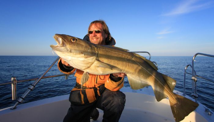

The German battleship Bismarck was trying to break out into the Atlantic to attack the Allied Shipping. To counter them, the British sent many ships, including the HMS Hood and HMS Prince of Whales.
It was a long-range engagement when the British ships opened fire, but their shells could not penetrate the armour of German battleships. In return, Bismarck fired a salvo that hit HMS Hood close to its ammunition magazine, leading to a deadly explosion that destroyed the vessel and killed all of its crew except the remaining 3.
Bismarck eventually broke through and continued its mission. However, it was damaged and sunk three days later by British warships.
The Denmark Strait was formed roughly 115,000 to 11,700 years ago during the last ice age. When the ice sheets advanced and then retreated over the North Atlantic, they created a landscape with a depression that gradually became the Denmark Strait over the course of thousands of years.


It is not possible to determine when the Denmark Strait was completely formed. But per scientists, it must have taken shape about 18,000 years ago during the Late Glacial Maximum.
Known for its stunning natural beauty and diverse marine life, the Denmark Strait is a popular place for nature lovers and adventurers.
A variety of activities can be done if one is visiting the Strait. First is whale watching. Since the Denmark Strait is home to many whales like humpbacks, minke and killer whales.
Tours are available from both Greenland and Iceland. One can also go fishing, kayaking and scuba diving in the waters to explore the underwater caves and shipwrecks. Also, several hiking trails on the Denmark Strait coast offer a breathtaking view of the mountains and coastline.
The Denmark Strait lies in the Arctic Circle and provides an opportunity to witness the magnificent Northern Lights in winter.
Sightseeing is also a great option since there are many historic sites and landmarks like ancient ruins, old villages and medieval-era lighthouses. One can also explore the fjords of eastern Greenland and their icebergs.
You might also like to read-
Disclaimer: The authors’ views expressed in this article do not necessarily reflect the views of The Marine Learners. Data and charts, if used, in the article have been sourced from available information and have not been authenticated by any statutory authority. The author and The Marine Learners do not claim it to be accurate nor accept any responsibility for the same. The views constitute only the opinions and do not constitute any guidelines or recommendations on any course of action to be followed by the reader.
The article or images cannot be reproduced, copied, shared, or used in any form without the permission of the author and The Marine Learners.






We believe that knowledge is power, and we’re committed to empowering our readers with the information and resources they need to succeed in the merchant navy industry.
Whether you’re looking for advice on career planning, news and analysis, or just want to connect with other aspiring merchant navy applicants, The Marine Learners is the place to be.