

Information concerning the navigational safety of ships was difficult to obtain in a timely manner in earlier days due to limitations of maritime communication equipment. This situation has improved to a great extent over the years. As technology advanced, the quality of shipboard communication equipment improved, providing navigational warnings for the intended voyage well in advance.
The Worldwide Navigational Warning Service (WWNWS) was established in 1977 for the promulgation of information on worldwide hazards to navigation for international shipping. Navigational warnings provide early information of important incidents which may constitute a danger to navigation. Many navigational warnings are of a temporary nature, but others remain in force for several weeks and may be succeeded by Notice to Mariners (NMs).
We as navigating officers must always aim at safe navigation. This can be achieved through sheer dedication and by taking the right action at the right time. Navigational deficiencies can be a major reason for a ship to be detained.
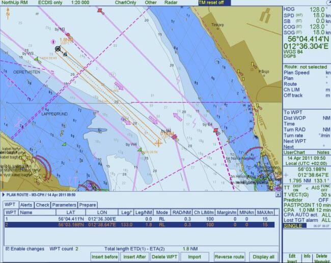
A good navigator plans each voyage carefully. On receipt of navigational warnings or any matter relating to the safety of life at sea, officers responsible should immediately check if they will affect the intended voyage. If that be so, these warnings should be plotted in the appropriate electronic and/or paper charts.
Navigational warnings are one of the most important things in chart correction. Navigational warnings are mainly of the following types-
• Casualties to large navigational buoys, primary lights or lightships.
• Changes in depth of water
• Dangerous wrecks or obstruction to navigation
• Floating dangers-like containers, drifting buoys, icebergs
• Newly established aids to navigation
• Gunnery or fire exercise areas and underwater activities in certain areas
• Vessels aground in approaching port areas
• Any changes or development of new buoyage system
• Gale warnings
There were times when weekly notices used to arrive very late onboard and chart corrections used to get delayed. What ensured the safety of the vessel is navigational warnings. Plotting the navigational warnings on charts ensures that the vessel is moving on a safe passage. Ignorance of navigational warnings especially in passage plan can be a reason for deficiency or non-conformity by port state inspectors as well.

SOURCES OF NAVIGATIONAL WARNING:
Navigational warnings can be received through Navtex and Inmarsat C, which is configured as EGC receiver. Navtex is a GMDSS requirement for the reception of MSI in coastal and local waters. Inmarsat C Safety Net is an internationally adopted, automated satellite system for promulgating navigational warnings and other safety-related information. Software like chartco and websites of the navarea coordinator can also provide EGC messages.
Care should be taken while taking nav warnings from the internet. No data should be obtained from unofficial websites. Information about official websites can be received from ALRS VOL 5 under the section of MSI (Maritime Safety Information). Gone are the days when we had to use hard copies of books for correction or to get any information. Now digitalized version of ALRS has made job onboard even simpler. Below mentioned are some attachments which will help in better understanding.
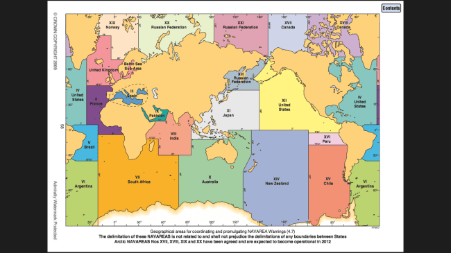
The WWNWS divides the world into 21 NAVAREAs which are identified by Roman numerals. The ship can sail in any of these 21 navareas. In order to obtain navigational warnings from any of the 21 Navareas, the particular area needs to be selected in the Inmarsat C. The best practice is to select all the navareas that will fall in the voyage at the commencement of the voyage. Officer in charge should ensure that their INMARSAT C EGC receivers are configured to receive MSI messages appropriate to their intended voyage.
RECEIVING NAV WARNINGS FROM INMARSAT C :
The EGC setup screen allows the officer to choose the NAVAREAs for which to receive messages. Below attached are pictures that will help us in understanding how to enable or disable the required navareas.
The NAVAREA/METAREA screen gives the option to enable or disable any of the 21 Navareas as required for the intended voyage.
RECEIVING NAV WARNINGS FROM CHARTCO:
Navigational warnings can also be derived from Chartco.
Navigational warnings can either be accessed from The NAVAREA warnings bar on the home page or from the NavAreaManager button in the Start-Main Menu.
On selecting navarea warnings, you will land in one of the 3 screens- NEW, INFORCE or CANCELLED depending on what outstanding actions you have.
The Setup option at the right-hand bottom allows the officer to set the Navareas that we wish to collect and display warnings for the intended voyage. By default, all Navareas are enabled and therefore updates for all 21 NAVAREAS will be collected. If the vessel doesn’t trade in any of the particular NAVAREAS, the same can be deselected. Click on Save to enable the changes.

After successful marking of the warnings in the relevant charts, the officer must click on ‘Apply’. The warnings are then removed from the New view.
On selecting a particular navigational warning message the text is displayed on the right-hand side window. The Print Selected option is used to print a hard copy of the message.
A list of in-force navarea warnings can be obtained from the Reports option. In-force list of warnings can be received from SAT C every week.
Navarea warnings can be shown on the map. Warnings are colour coded to indicate their status. New is in red, in force in amber and cancelled are in blue.
The first thing that an officer of the watch must do on receiving a Navarea warning is to check if it will affect the current voyage. If it falls within the route, it should be plotted without further delay and should be brought to the attention of the Master and other watchkeeping officers. If the warning is out of route, the same shall be marked by the officer and filed.
While plotting a Navarea warning, care should be taken that the minimum information required is displayed without obscuring other chart data.
‘User chart’ can be used to plot navarea warnings on Ecdis. It can be named after the warning number. On cancellation of the Navarea warning, the user chart is deleted. For example, the above screenshot shows a firing exercise area that is to be avoided. ‘Notes’ can be used to display the minimum information required without cluttering the chart area-in this case the warning number and the text of the warning.
We must understand the fact that handling navarea warning messages are equally as important as plotting them. A systematic procedure should be adopted while dealing with navarea warnings. Navarea warnings should be handled in such a fashion that every officer should be able to find out with ease which all warning messages are plotted and what charts do they affect.
How do we know if a navarea message has been cancelled?
Navarea warnings are typically cancelled for three reasons:
The in force list of warnings can be received through SAT C every week from which the officer can determine the notices that are cancelled. Also, we can get to know about cancelled notices through Chartco software using the Cancelled view as shown below.
On receiving the in force list of warnings, the officer of the watch must first identify the cancelled warnings.
The Navarea file must then be updated and the cancelled warnings should be segregated and put in the Cancelled section.
If paper charts are still being used, the cancelled warnings that have been plotted on the charts must be deleted along with the warning number that is written at the bottom of the chart.
The navigator’s chief responsibility is the safety of the vessel and its crew. Fulfilling this duty consists mostly of ascertaining the ship’s position and directing its course so as to avoid dangers. Thus we see that navigational warnings play a major role in enhancing the safety of the ship. It is important to monitor navigational warning broadcasts prior to sailing.
In some underdeveloped parts of the world, the coastal countries lack the facilities to broadcast navigation warnings for adjacent waters. A hazardous situation may exist and may go unreported unless a passing vessel’s crew takes notice and makes a report to one of the WWNWS Navarea Coordinators. This will not only improve the safety of navigation at sea but also help prevent any untoward incident from happening.
Disclaimer: The authors’ views expressed in this article do not necessarily reflect the views of The Marine Learners. Data and charts, if used, in the article have been sourced from available information and have not been authenticated by any statutory authority. The author and The Marine Learners do not claim it to be accurate nor accept any responsibility for the same. The views constitute only the opinions and do not constitute any guidelines or recommendation on any course of action to be followed by the reader.
The article or images cannot be reproduced, copied, shared or used in any form without the permission of the author and The Marine Learners.








We believe that knowledge is power, and we’re committed to empowering our readers with the information and resources they need to succeed in the merchant navy industry.
Whether you’re looking for advice on career planning, news and analysis, or just want to connect with other aspiring merchant navy applicants, The Marine Learners is the place to be.